Frequently Asked Questions
Maptaskr Customer Support
What issues are included in Support?
For Customers who are current license holders, Maptaskr provides product support which includes;
-
Configuration and basic “how-to” questions
-
Best practice advice
-
Access to major and minor releases (Based on product specific release cycle)
-
Bugs or defects in one of the Maptaskr solutions. Bugs or defects are defined as a verifiable and reproducible software problem or error that causes a failure of an unmodified version of Maptaskr's software product(s) to operate substantially in accordance with applicable end user documentation.
What issues are excluded in Support?
-
Troubleshooting of software that has been modified by the end user
-
Products installed outside of accordance with the Product Documentation
-
Issues with Third Party technologies (such as Javascript)
-
Custom solution development or integrations
What SLA do customers get?
Support subscriptions include technical support, maintenance, and regular updates, with the following SLA terms:
| Severity | Standard Support Response SLA |
|---|---|
| Severity 1 | 1 business day |
| Severity 2 | 2 business days |
| Severity 3 | 3 business days |
| Severity 4 | Best efforts |
-
Severity 1 (S1) - A production environment event where the Maptaskr solution is completely inoperable or inaccessible to all users and has a severe impact to business continuity.
-
Severity 2 (S2) - A production environment issues with severe performance impact or features not operating as documented that impact a majority of the solution or users.
-
Severity 3 (S3) - Issues with performance or features not operating as documented that impact a minority of the solution or users.
-
Severity 4 (S4) - Questions of how to use Maptaskr or related to issues with performance. Inquiries may also relate to potential feature requests for the Maptaskr solution, which will be recorded, and the cases will then be closed out.
Maptaskr does not offer formal SLAs of resolution times. Resolution is dependent on the Maptaskr evaluation of issue severity, issue nature and business impact. High severity items will be escalated as required should the issue pose a risk to customers business continuity. In situations where a urgent hot fix update is required, Maptaskr will provide customers with a specific interim version update to address any items as required and agreed.
What is the best way to contact Maptaskr Support and raise an issue?
Our Support Contact details, and operating hours are as per below:
-
Support requests submitted to support@maptaskr.com
-
Support Hours: 8am-5pm Australian Western Standard Time (AWST)
All support is provided following ITIL based incident management, problem management and service request fulfilment processes.
What if we have general feedback or feature requests?
We love receiving feedback from our customers and partners alike, if you have any feedback, just let us know as it helps us grow and evolve the solution. All feature requests will be assessed for feasibility, complexity, and alignment to the product roadmap. All changes must be discussed and agreed with Maptaskr prior to making any commitment to customers, whilst endeavouring to be agile and customer-centric it may not be possible to accommodate every change request or make these in a specified time frame.
What if we have elevated support needs?
Maptaskr can provide Premium support options for your implementation in the need arises. Please contact us to discuss these options.
What updates are available, and how are customers notified of new releases?
Depending on the product, there are periodic major (known as Customer Releases) and minor releases that are available to customers. These contain a mixture of feature enhancements and product refinements which vary on product specific release cycle (i.e. Dynamics 365, Power Apps & Power Pages).
Major release updates
-
These Customer Releases are published and available from AppSource (D365 and Power Apps only) when setting up and installing Maptaskr on a new environments. Typically, Maptaskr provides 2 major updates a year, aligning with Microsoft's Power Platform wave releases.
-
For existing implementations, Maptaskr will provide release notices* of the Customer Release as and when they are available. Note: Auto notifications via the platform will be available in the future, the feature is currently in preview from Microsoft.
Installation of major updates are highly recommended to ensure the installation of Maptaskr remains stable and caters for any underlining updates to the base platforms on which it operates.
Minor releases updates
Minor releases are only available to existing customers and on request or if required to address an urgent bug fix or product update. Maptaskr will provide release notices* of the minor releases as and when they are available. Note: Minor releases are not regression tested as extensively as Customer Releases and thus may contain issues which need to be considered prior to installation.
*Release notices
Maptaskr will provide notices to appropriate customer contacts as nominated. These notices will indicate the availability of the release, release notes, instructions for deployment (if required) and access to the solution files related to the release.
We host solution files of the latest versions of our software on this website, and you can find these releases by following the links below:
What Projection types does Maptaskr natively use out of the box?
Being a web based map technology Maptaskr natively renders maps in Web Mercator WGS84 EPSG:3857 - https://epsg.io/3857
When loading layers, or rendering uploaded shapes Maptaskr converts the source projection to EPSG:3857, when displaying coordinates to the user, Maptaskr then converts the coordinates to EPSG:4326. This is due to how our base framework operates.
Maptaskr will save shape polygons to the Dataverse in EPSG:3857, but will not modify the original uploaded shape files. These are attached along with the visual representation to records without modification to ensure data integrity.
What projection types can Maptaskr support?
Maptaskr natively supports loading layers and shape files in various coordinate systems. For a detailed list of supported projections, please visit Supported Projection List
Additionally, Maptaskr can be configured to restrict uploads of shape files to a specific projection, or list of projections. For example, Maptaskr can be configured to prevent any file upload that is not GDA2020 or GDA94 (commonly used projections for Australian Government)
Whilst the visual representation of the shape is converted to the Maptaskr native projection (EPSG:3857) to allow Maptaskr to render items on a map, the original shape files (if any) are uploaded without modifcation.
What about when a user draws a point, line or polygon on a Maptaskr map?
When users draw (annotate) on the map this is natively captured and rendered in the native Web Mercator WGS84 EPSG:3857. This drawing (annotation) is then uploaded to Dataverse in a custom geoJSON format in EPSG:3857.
What about when supported files are uploaded to the Maptaskr map?
When a user uploads a supported file (Shapefile(.zip), KML, KMZ, GeoJson, TopoJson, GPX, CSV) to a Maptaskr map the geospatial data is converted our the native projection required Web Mercator WGS84 EPSG:3857. A valid supported file uploaded will contain the details of what projection the data is in and Maptaskr utilizes a Proj4 library to convert the data to the target native projection. This is done in browser.
When a user uploads a Shapefile, the original file uploaded is retained as an attachment (Annotation) against the related record. In instances where data accuracy and integrity are important to the business process being supported by the overall solution, the stored Shapefile can be utilized to ensure data being synced back to ArcGIS remains as accurate as needed.
My Power Pages form is loading but the Maptaskr Control isn't, what is the issue?
If the page is loading successfully, and the Maptaskr control may be failing to download. This can be verified by checking the network traffic tab in your browsers developer tools.
The issue may not have anything to do with Maptaskr control specifically, but rather the activation of the Power Pages Content Delivery Network setting.
To verify if this has been enabled go to Power Platform admin center, select the website you are having issues with and check to see if the below setting is active.
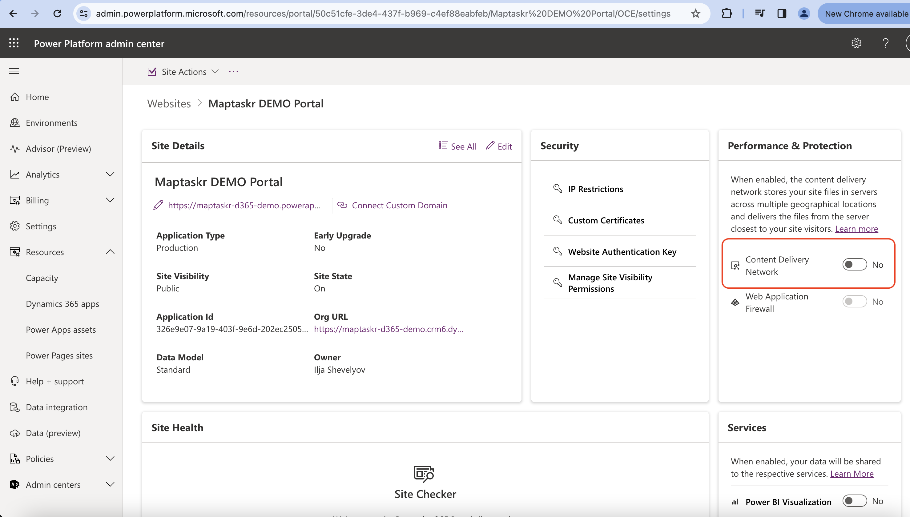
We have confirmed that the Power Pages CDN does not yet support files over 15MB in size which is preventing the loading of the required Maptaskr script files.
Deactivating this CDN setting will resolve the issue.
ArcGIS Layer Integration
We have customers that adopt different approaches to allowing Maptaskr access to their ArcGIS layer services, namely direct native ArcGIS integration (the vast majority of customers), or proxied via some integration layer.
Direct native ArcGIS integration
In general, most customers are satisfied with direct native ArcGIS integration as this in supported OOTB by Maptaskr with minimal configuration and adopts the native manner ArcGIS works with publishing and serving up geospatial layers for other systems to consume. Acceptable security constraints can be applied at 4 levels – ArcGIS, D365, Maptaskr and lastly, if determined to be necessary, via appropriate network traffic routing constraints and security management (e.g. IP access control etc).
This approach is very much industry standard and acceptable, with numerous examples of ArcGIS services available via publicly available endpoints globally. Using this approach, you will get the best balance of security and performance when it comes to integrating with ArcGIS services.
Integration via an Integration Platform (iPaaS)
In a few instances we see customers wanting to route integrations, including geospatial services, via an enterprise Integration Platform, such as APIM. There can be varying reasons for this, though typically this is due to an enterprise-wide decision to apply the same integration pattern as with their other integrations for security or conformity purposes. Maptaskr does support integration via an Integration Platform, with layer connections being configurable to pass appropriate parameters to negotiate their way through. In saying this there is typically more effort in the setup of these layer services via the iPaaS, and due to the nature of geospatial services being very ‘chatty’, there is a very noticeable performance hit of these layers rendering.
One customer utilises a combination of direct integration and some layers integrating via an APIM based integration layer. Their decision to integrate specific layers via APIM was mainly for conformity, due to their need to access a third-party SAP solution which is used for asset management and included a provider managed ArcGIS instance. In this instance, there was more effort for the implementation team to establish access to these layers, and there is a noticeable performance drop in accessing these layers as opposed to the internal ArcGIS Enterprise services.
Mobile Device Minimum Recommended Specifications
We do not have any specific information around RAM and ROM requirements, however the mobile version of Maptaskr has been successfully tested on the following devices:
-
Google Pixel 5 - Android 13, 8GB RAM
-
iPhone 12 Pro Max - IOS 16, 6GB RAM
The difficulty in identifying minimum requirements stems from the fact that Maptaskr can be configured to render any number of layers, and base-map data. This will mean that the minimum requirements per client implementation will change.
A good baseline would be to get the client to match the minimum Microsoft Power Apps specifications: https://learn.microsoft.com/en-us/dynamics365/field-service/mobile-power-app-system-requirements
We would then suggest they undertake performance testing after you have configured the default layers, and maps to identify their specific minimum requirements for their needs.
Can Maptaskr be performance tested?
As Maptaskr is a Client-side application (completely written and running in Javascript running on a browser) and contains no server-side components, we have no need to run load testing on the solution.
There can be a million concurrent users using the app independently (on different devices) with no impact on the “Maptaskr” solution. The perceived performance is driven by the performance of the clients underlying D365 environment, and the clients ArcGIS Services ability to return map tiles, or features – Neither of which we have access to, nor control of.
The performance of the Maptaskr control can only be measured by the performance of the browser running the JavaScript. More powerful PC’s running the latest Chromium browsers will be able to connect to, and stream multiple layers without issue.
We do device-based testing prior to our releases, and test IOS, Android, Chromium, and Safari across an SOE environment of common devices (usually the previous few years mobile phones and laptops) and are continuously improving performance version on version, however have had no real issues with performance.
The only one device that has caused issues is the IPAD – these devices seem to be underpowered compared to other devices of similar age, and usually lack the ability to load multiple layers with many features at the same time. This can be resolved by reducing the number of layers loaded by default.
Historically one of our customers ran a performance test against their solution, and realised that performance metrics were not related to the Maptaskr/D365 Controls, but rather their GIS systems, especially ArcGIS Servers in their Test environments, which didn’t have enough memory allocated, resulting in tiles/data not loading on the map in a timely fashion.
What can impact the performance of things loading in Maptaskr?
Typical things that affect the performance of things loading with the Maptaskr solution are -
-
General internet connectivity (Main cause of performance issues).
-
Performance of the D365 or Power Pages environment - Note: Microsoft typically scales down performance of Sandbox environments compared to Production instances, this needs to be taken into consideration when evaluating performance of your implementations as a whole.
-
GIS systems performance, especially ArcGIS Servers in Test environments not having the same specs as their production counterparts (such as memory allocation) which results in tiles/data not loading on the map in a timely fashion.
How are basemaps configured in Maptaskr?
By default the basemaps utilised by Maptaskr are picked up from the Manage Services configured services within your Maptaskr Configuration area. Here you can setup a provider and choose which provider to use for your basemap, amongst other core map services used throughout Maptaskr.
Services that are supported to provide basemaps include -
| Provider | Supported |
|---|---|
| Bing | Yes |
| ArcGIS | Yes |
| HereMaps | Yes |
| OpenStreet | Yes |
| AzureMaps | Yes |
We have it configured to use ArcGIS basemaps, but the only options appear to be Map and Satellite and we would like to add different ArcGIS basemaps. How do you go about doing that?
Yes, you are able to configure custom basemaps as either an additional basemap available to users, or set it as the default basemap used by Maptaskr.
To do this you simply need to add the basemap service as a layer and check the Add as Custom Basemap checkbox. If you wish to make the layer the Default basemap used, check the Add as Default BaseMap checkbox. You can add multiple additonal basemaps for users to access, but only one default basemap as you'd expect. Also, if you add your basemaps to their own group and only set admins to be able to see them, they will not be visible to users from the Layers section of Maptaskr and keep things nice and clean.
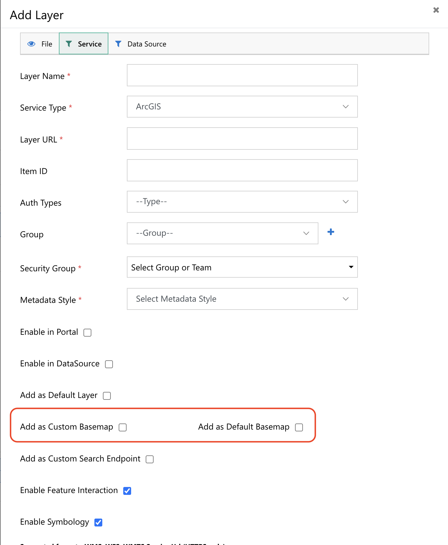
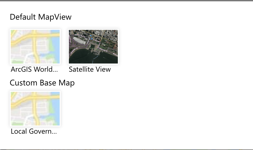
Example of setting ArcGIS World as the new default basemap below.
The map it currently uses appears to be their legacy ArcGIS basemap which is no longer being updated. They recommend switching to new services that are tiled based. Can Maptaskr support tiled-based basemap services? If so, can these be configured?
If your installation of Maptaskr uses legacy ArcGIS basemaps, we suggest upgrading to the latest version as this has been phased out and replaced with Vector Tile basemaps. We host solution files of the latest versions of our software on this website, and you can find these releases by following the links below:
Maptaskr to ArcGIS deployed in a private network (e.g., on premises). What would be your recommendation to for Maptaskr to get info from ArcGIS in this scenario?
If the ArcGIS server is on a private network and not available publicly, then the Maptaskr for Power Pages will not have access to the ArcGIS layers.
If this is required, you will need to create a publicly accessible endpoint, and then we would recommend a rolling token for public access to select ArcGIS layers.
We would suggest creating an external accessible APIM layer or similar to allow select layers access from an external endpoint.
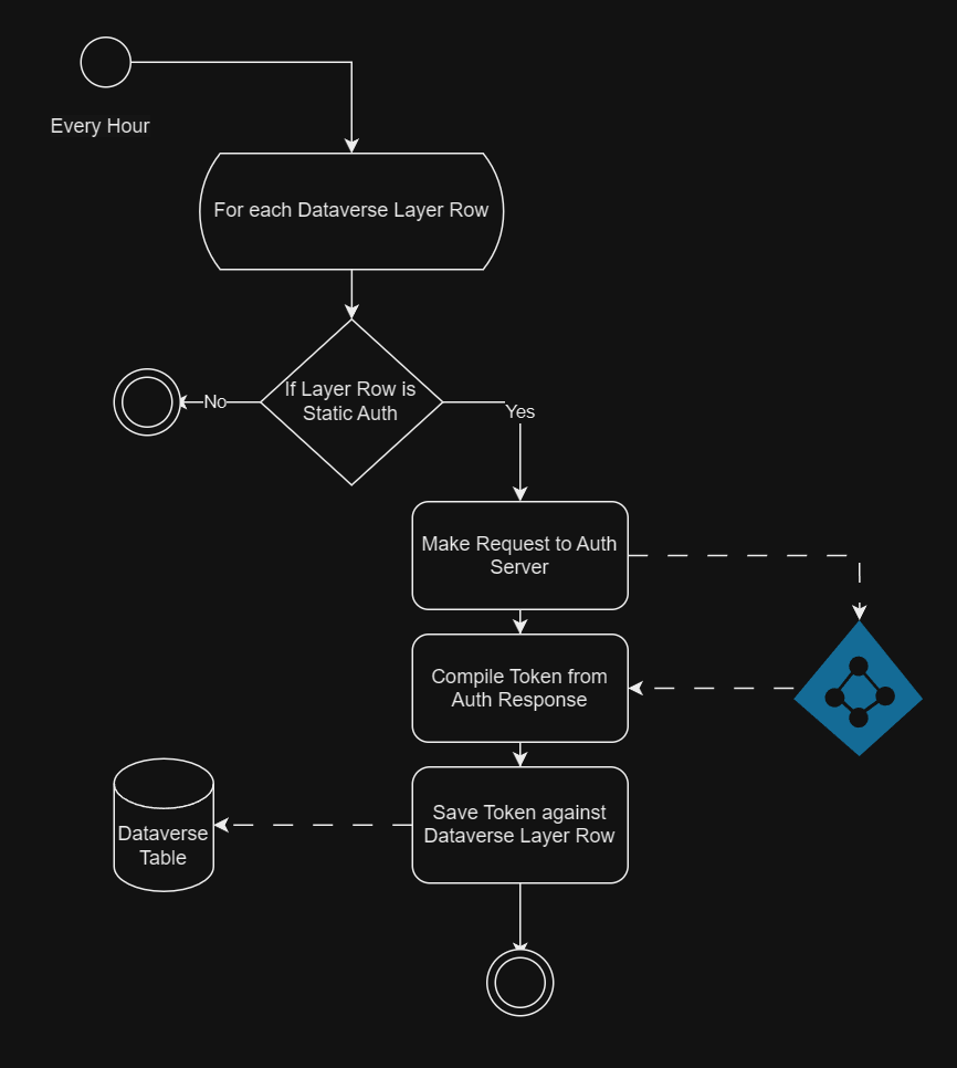
Our customers have multiple ArcGIS systems, how do you recommend we use Maptaskr to get data from multiple ArcGIS systems? For example, can I assume each layer in Maptaskr can only load data from only one ArcGIS URL endpoint?
This is correct. A layer can only load from a single URL, and Maptaskr Configuration was designed for a single Enterprise endpoint.
However, if you utilise the static tokens, you can load one layer from one endpoint, and another layer from another endpoint, you need only authenticate to the respective ArcGIS server with a service account Client ID and Secret and save the token to the layer table.
We have an example power automate flow of how this is achieved.
This process would be similar to the publicly accessible layers.